26 Course Details
NEW COURSE due to 2026 SNOW CONDITIONS – updated 4/15
We are ever grateful for this community’s patience as our planning team works to adapt the course for the 50th year of PPP to meet the unfortunate snow conditions of this past winter season. We are happy to report that, with the support of Mt. Bachelor, the SELCO Pole Pedal Paddle’s first two legs will still take place on the mountain, despite the lack of snow and the ski area’s closure in April.
Maps and Course Descriptions for the first two legs of the 2026 course at Mt. Bachelor are now available on our website. We’ve also provided links to view courses on Strava to see all stats. Please keep in mind that course may be tweaked slightly for exact conditions the week prior to PPP depending on how the snow melts. We don’t anticipate any changes to be significant enough to reshare maps.
The first leg will start with a run-up from the Nordic Center parking lot to Blue Jay’s trail. Runners will proceed with a 2.8 mile “Mountain Run” that will cross over to the West Village side of the mountain and will feature approximately 400 ft of elevation gain before the course descends towards the base of Pine Martin. After a transition zone near West Village Lodge the second run leg at Mt. Bachelor will be a “Fun Run” – 1.3 miles, relatively flat, and hopefully including some fun surprises along the way, until they reach Transition 2, which will take place in the middle parking lot near Sunrise Village Lodge. Once racers are on the bike course, they can expect the course to be exactly the same as the last two years, including a 5.2 mile River Run and the final .4 mile sprint to the finish.
As soon as we finalized all logistics related to the course changes we will share PPP’s 2026 Competitor’s Guide as well as continue to update our website’s “Racer Info” section. Please be prepared to read about NEW transportation logistics at Mt. Bachelor, including details about where to park, the inter-lodge shuttle that will be running, and recommendations for each category that will cover how to stage and how to order your race participants for the smoothest transitions on race day.
Thanks for sticking with us through the wild ride that is the 50th year. Just like the first official race during the drought of 76/77, this PPP (Peak Pedal Paddle?) will certainly be one for the books!
TRANSITIONS & TIMING
You will have a transponder that must be worn for every leg. If it is not worn, you will not get a time. There will be only one transponder per team and it must be handed off at each transition, starting with the Mountain Run and finishing with the Sprint.
MOUNTAIN RUN LEG
This year’s edition of the SELCO Pole Pedal Paddle will start near the Nordic Center of Mt. Bachelor. Racers will have a short climb up to to the top of Blue Jay’s trail and continue around the parking lot towards the base of Red Chair. Once racers reach the base of Pine Martin they will start their ascent up the Evergreen Trail which includes a series of switchbacks. After about 400ft of of vertical climbing, racers will descend back down and across the mountain using a service road trail until they reach transition one, which will be set-up outside the West Village Lodge. At that point individual racers will continue on to the Fun Run while racers in the pairs and teams categories will likely hand off to a new runner. It is possible some sections of the Mountain Run will have snow, however our team will do our very best to clear at least narrow sections of the trail. Total distance of the Mountain Run is 2.8 miles.
See more detailed map on Strava by clicking link in title. Or, click here to access GPX files that can be uploaded to your platform of choice.

MT. RUN – FUN RUN TRANSITION
This first transition will take place near the base of Pine Martin lift, right outside West Village Lodge. More transition details coming soon. Transition maps will be included in 2026 Competitors’ guide.
FUN RUN LEG
See more detailed map on Strava by clicking link in title. Or, click here to access GPX files that can be uploaded to your platform of choice.

FUN RUN – BIKE TRANSITION
Supported by Sunnyside Sports
The Fun Run-to-Bike Transition will take place in the Sunrise Parking lot. Bikes will be organized in shoots, as they typically are, by last digit of bib number.
A: 0-1 | B: 2-3 | C: 4-5 | D: 6-7 | E: 8-9
More details about staging bikes, coming soon!
BIKE LEG
Sponsored by East Cascade Women’s Group
Upon leaving the Transition Zone, bike racers will proceed out of the Sunrise Parking lot towards Bend for about 19 miles. ABSOLUTELY NO DRAFTING IS ALLOWED WHILE ON THE BIKE COURSE. PLEASE SEE PPP DRAFTING POLICY FOR MORE DETAILS.
There will be downhill car traffic between the Bike Start and the Sunriver Junction. After Sunriver Junction, the large majority of downhill traveling cars will be detoured through Sunriver. There will, however, still be a few cars (who have been issued special passes) allowed on the downhill side of the road. There will ALWAYS be uphill traffic. Please be aware of vehicles while racing and pay attention to flaggers and volunteers on the course as well as the Deschutes County Sheriff’s Office, which will be present at the Sunriver Junction.
The course is primarily downhill with one uphill climb after the Sunriver Junction. Parents may not ride with their children on bike course. ONLY those competitors who are doing the Bike Leg are to be riding on the course (extra riders impede safety). Remember to have your Bib# visible as you approach the Bike Finish for the volunteers to call your number for your teammate or support crew to be ready. The Bike Finish will be just before the Reed Market Roudabout.
Below map shows traditional course, which has only be slightly changed for 2026. See more detailed map of 2026 course on Strava by clicking link in title. Or, click here to access GPX files and upload to your platform of choice.
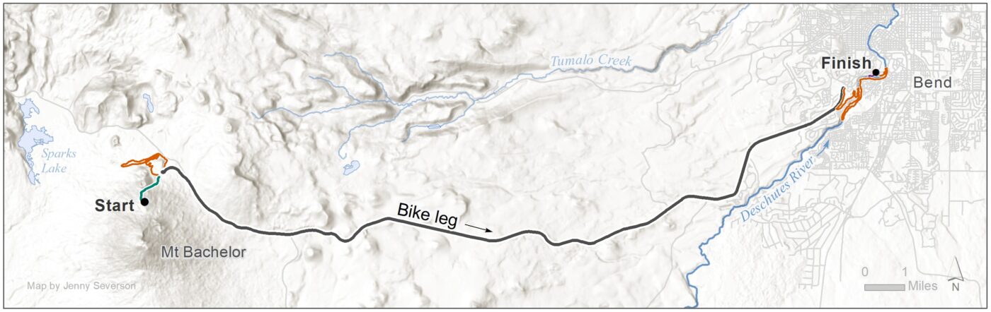
BIKE – RIVER RUN TRANSITION
Sponsored by Athletic Club of Bend
As you approach the Bike-to-Run Transition be sure to slow down and look for signs. You will be directed to exit the bike lane on Century Drive and enter a small paved path that will lead you to the Transition Zone. The path is only wide enough for 1-2 bikers, so be prepared to yield to those in front of you. If all goes according to plan, volunteers and transponder readers will support the transition with teammates by calling out approaching numbers. For racers who may need it, there will be a clothing/shoe drop-off area in this Transition Zone for racers to use the morning of the race.
RIVER RUN LEG
Sponsored by K2 Stone
The 5.2 mile course starts at the Athletic Club of Bend, which hosts the bike-to-run transition. Runners will start up the Haul Road Trail from the Athletic Club and then turn left on to Mt. Bachelor Drive to run through Mt Bachelor Village. As they approach Touchmark, runners will turn right and enter Touchmark roads, and ultimately access the River Trail.
There is a short-cut for 12 and Under racers who choose to do the shortened course, which will allow them to access the River Trail earlier in the course. The total distance of the shortened course is 3.7 miles.
Once on the River Trail, all runners will continue south to the far footbridge, cross the river, and return through Farewell Bend Park towards the Old Mill. There will be a short section of the run course where sprinters and runners are sharing the same trail. Runners must keep right on that section. Once they reach the Old Mill, runners will cross the flag bridge and run towards Riverbend Park, entering the run-to-paddle transition just after the dog park.
The run course provides runners with a wide variety of surfaces: dirt, pavement, sidewalk, gravel/bark chips, pavers, wooden planks and even one or two rocky sections!
To view the PPP Run Course on Strava, click HERE. If you’d like to see how it compares to the shortened course for 12 & Under racers, click HERE.
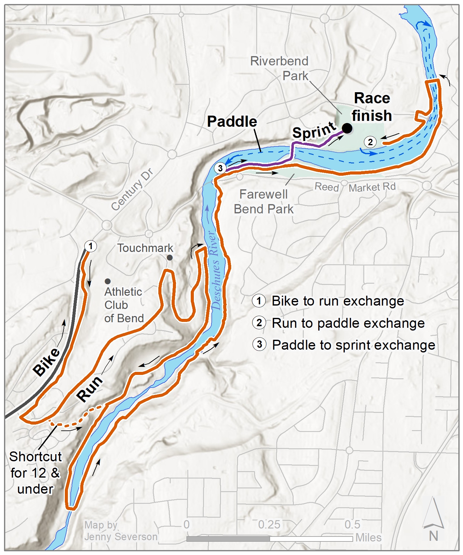
PADDLE LEG
Sponsored by Tumalo Creek Kayak & Canoe
Paddlers will launch from the downstream side of the beach at Riverbend Park and travel downstream for about .5 miles. We ask that paddlers do their best to stay to the left of the buoys for the entire course to ensure they do not impede other racers. However, ALL RACERS MUST take the turn-around buoy, which is just beyond the flag bridge in the Old Mill District, in a clock-wise direction. After racers turn, they will paddle upstream for about 1 mile, doing their best to stay to the left of the buoys, as they return. The finish and take-out for the Paddle leg is located on the opposite side of the river at Farewell Bend beach.
Tumalo Creek Kayak and Canoe will have rafts and guides to monitor the course and assist in an emergency. Approved PFDs (personal floatation devices) must be worn at all times in the paddle leg.
To view the PPP Paddle Course on Strava, click HERE. Please keep in mind that the turn around point will vary slightly year to year depending on water levels.
PADDLE-TO-SPRINT TRANSITION
Sprinters looking for this Transition Zone MUST NOT travel on course in the opposite direction. Instead, utilize the paved path closest to Reed Market Road and walk towards the beach/Bill Healy Bridge until you come to the Paddle-to-Sprint Transition. It is a very tight area and we recommend spectators watch from the Bill Healy bridge, if they must spectate near this transition.
Paddlers will receive help exiting the water on the downstream side of Farewell Bend beach. Teammates must wait off the beach and off the course until they hear their bib number being called. Once the number has been called, sprinters may move onto the beach, which will be the “Tag Zone.” BE AWARE THAT SPRINTERS ON TEAMS AND PAIRS WILL BE CROSSING THE RUN COURSE to access the beach. Please give runners the right of way.
Boats will be organized by bib number once they exit the water at Farewell Bend Park. We ask that racers, a teammate, or proxy pick up the boat used for the paddle leg within 40 minutes of crossing the finish line. If you are racing in a Team Category, you have the option to tag your sprinter and then paddle your boat back to Riverbend for self-storage. If you opt for self-storage be sure to TELL YOUR VOLUNTEER YOU NEED TO KEEP YOUR BOAT. You’ll still need to run up to the beach to tag your sprinter. If you leave your boat in Farewell, you must bring a bib number with you to pick-up. Boats that are not claimed by 4pm will likely be left unattended at that time.

SPRINT LEG
Sponsored by True Wealth
The final sprint starts at the paddle take-out on the beach of Farewell Bend Park. Sprinters will run along side the run course and must be sure to keep left until they reach the bridge the connects Farewell Bend to Riverbend Park. Sprinters will run over the bridge and follow the sprint course where they will enter a final race shoot on the main lawn at Riverbend Park. On this sprint course there are 2 short stints of lawn running, but the large majority is on pavers.
At the finish, please enjoy beverages from Bigfoot Beverages.
To view the PPP Sprint Course on Strava, click HERE.