2024 Course Details
ALPINE SKI LEG – Sponsored by Mt. Bachelor and MBSEF
The course starts at the top of the Red Chair. There will be marked areas for each wave to line up to wait. When your wave is called to move forward, racers will take off skis at the top of the run. Please do not move other competitor’s skis, it is a first-come, first-serve placement for skis.
After skis are removed, racers will walk down to the bottom of the 200 foot sprint. Length will vary due to snow conditions. Race officials will help you line up correctly and will call the start of your wave.
Racers will sprint up to their skis, put them on, and then ski down Leeway trail. All racers must obey the control gates. Gate keepers will be monitoring the course and if you miss a gate you must re-enter or you could receive a time penalty.
The course is a beginner/intermediate run. The course may change slightly year to year, due to snow conditions.
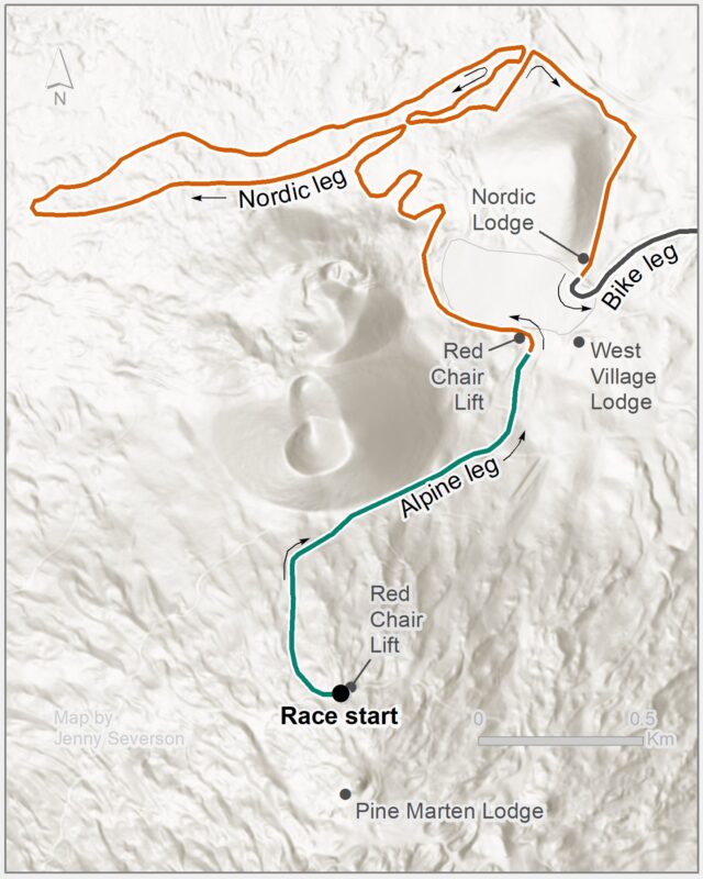
NORDIC SKI LEG
Note: we don’t anticipate needing to make changes our Nordic Course for 2024, but we will keep you updated if the course is revised for any reason.
The Nordic ski course was revised in 2018 to better protect it from potential snow melt and race day weather with much of the course staying on the south side of the Mt. Bachelor Nordic Trails in the protection of magnificent old growth timber. The trail no longer goes toward the north side of the trails where it is more open and exposed to storm winds and direct snow melting sun.side of the trails where it is more open and exposed to storm winds and direct snow melting sun.
In addition, the new course doesn’t quite go as low in elevation, and it has a nice flatter section before the climb back to the Mt. Bachelor Nordic Center.
As in the past the course circles the West Village Parking Lot, before dropping down Blue Jay’s to Junction 11 where it follows the traditional course down to Junction 19. It then takes Woody’s Way through Junction 18 going all the way up to Junction 6. There the trail takes a right to junction 10 and continues on a nice easy loop on Blue Jay’s to Junction 11 where it turns left and returns to Junction 10 though Emil’s clearing still with easier terrain. From Junction 10 the course, like in the past, climbs up to the Common Corridor and returns back to the Mt. Bachelor Nordic Center and the bike transition.
Total distance of the Nordic Course is 6km (or 3.7 miles).
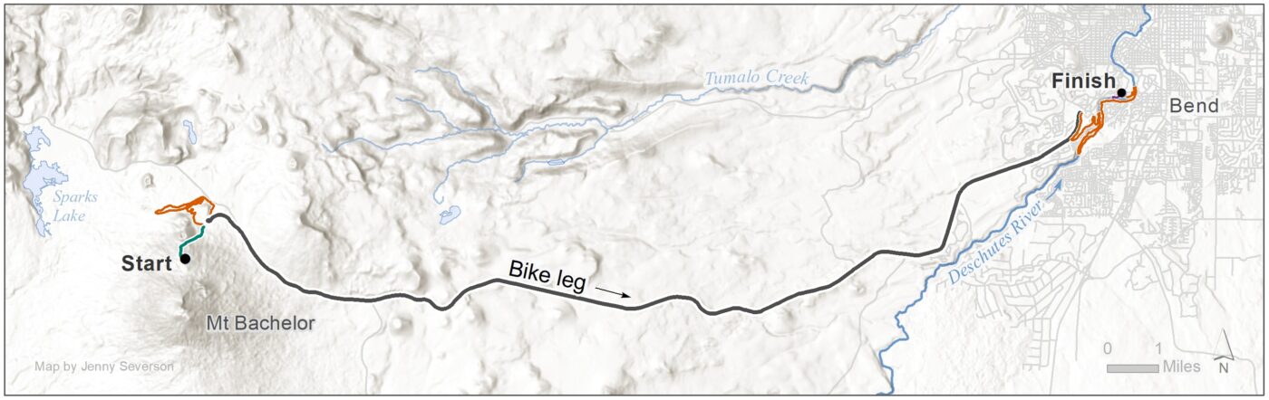
BIKE LEG – Sponsored by East Cascade Women’s Group
Upon leaving the Exchange area, bike racers will proceed out of the West Village Parking lot towards Bend for 22 miles. ABSOLUTELY NO DRAFTING IS ALLOWED WHILE ON THE BIKE COURSE. PLEASE SEE PPP DRAFTING POLICY FOR MORE DETAILS.
There will be downhill car traffic between the Bike Start and the Sunriver Junction. After Sunriver Junction, the large majority of downhill traveling cars will be detoured through Sunriver. There will, however, still be a few cars (who have been issued special passes) allowed on the downhill side of the road. There will ALWAYS be uphill traffic. Please be aware of vehicles while racing and pay attention to volunteers on the course as well as the Deschutes County Sheriff’s Office, which will be present at the Sunriver Junction.
The course is primarily downhill with one uphill climb after the Sunriver Junction. Parents may not ride with their children on bike course. ONLY those competitors who are doing the Bike Leg are to be riding on the course (extra riders impede safety). Remember to have your Bib# visible as you approach the Bike Finish for the volunteers to call your number for your teammate or support crew to be ready. The Bike Finish will be just before the Mt. Washington Roundabout.
RUN LEG – Sponsored by the Athletic Club of Bend
The 5.2 mile course starts at the Athletic Club of Bend, which hosts the bike-to-run transition. Runners will start up the Haul Road Trail from the Athletic Club and then turn left on to Mt. Bachelor Drive to run through Mt Bachelor Village. As they approach Touchmark, runners will turn right and enter Touchmark roads, and ultimately access the River Trail.
There is a short-cut for 12 and Under racers who choose to do the shortened course, which will allow them to access the River Trail earlier in the course. The total distance of the shortened course is 3.7 miles.
Once on the River Trail, all runners will continue south to the far footbridge, cross the river, and return through Farewell Bend Park towards the Old Mill. There will be a short section of the run course where sprinters and runners are sharing the same trail. Runners must keep right on that section. Once they reach the Old Mill, runners will cross the flag bridge and run towards Riverbend Park, entering the run-to-paddle transition just after the dog park.
The run course provides runners with a wide variety of surfaces: dirt, pavement, sidewalk, gravel/bark chips, pavers, wooden planks and even one or two rocky sections!
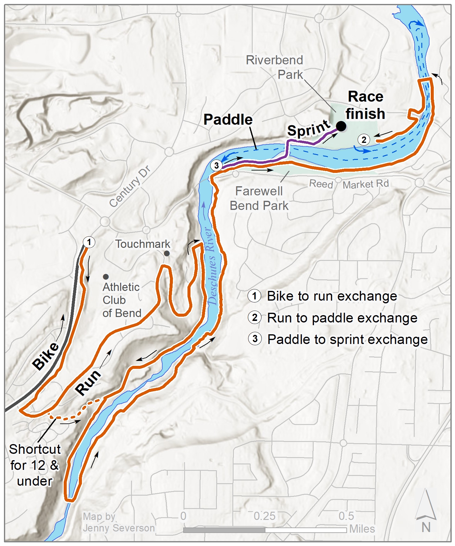
PADDLE LEG – Sponsored by Tumalo Creek Kayak and Canoe
Paddlers will launch from the downstream side of the beach at Riverbend Park and travel downstream for about .5 miles. They will turn around shortly after the Flag Bridge in the Old Mill and paddle upstream for about 1 mile until they reach the takeout at Farewell Bend beach.
SPRINT LEG – Sponsored by Hotel Peppertree Bend
The final sprint starts at the paddle take-out on the beach of Farewell Bend Park. Sprinters will run along side the run course and must be sure to keep left until they reach the bridge the connects Farewell Bend to Riverbend Park. Sprinters will run over the bridge and follow the sprint course where they will enter a final race shoot on the main lawn at Riverbend Park. On this sprint course there are 2 short stints of lawn running, but the large majority is on pavers.
At the finish, please enjoy snacks from Trader Joe’s and other beverages from Bigfoot Beverages.